
Theun-Hinboun Dam Hydropower Info by Hobo Maps - Go to Hydropower Projects Page - - - Home
Theun-Hinboun can be pronounced like "Tune hin boon".
The Theun-Hinboun weir and head pond are located about 6 km north of Ban Na Hin town (also known as Khoun Kham). The project is near National Road 8 about 100 km upstream from where the Nam Kading/Nam Theun (river) joins the Mekong near Pak Kading. The project has a presence in both Bolikhamxay and Khammouane Provinces of Lao PDR.
The Nam Theun river mysteriously changes its name to Nam Kading river about where the Theun Hinboun hydropower project exists. Very strange that the same natural river suddenly changes its name. Not sure why but probably some historic origin.
Satellite image below shows project locations.
Theun Hinboun Power Company (THPC) is the project owner with Electricite du Laos (EDL GEN) as a 60% shareholder, Norwegian Statkraft SF owning 20% and GMS Lao Company Limited with a 20% share.
The initial project cost US$ 260 million to construct with direct shareholder investment covering about 30% of total project cost while the remaining 70% was raised from international bank loans.
Asian Development Bank (ADB) loaned $60 million to implement this first joint-venture hydropower project between government of Laos and foreign investors (the first non-recourse financed public-private partnership project in Lao PDR).
Satellite image below shows original weir & head pond as well as expansion dam and reservoir:

Theun-Hinboun weir and head pond images below at coordinates 18°15'39.6"N 104°33'43.2"E (18.261000, 104.562000):


The project celebrated its 25th anniversary on March 31, 2023.
The original project harnessed the power of the Nam Theun, using the run-of-the river dam at Ban Kengbit. Using a combination of radial gates, flap gate and a weir, this dam diverted around 110 cubic metres per second of the river's flow down a 6-km tunnel to a ground-level powerhouse in Khounkham, in the Nam Hai valley. The water falls about 235 meters.
In 1998 the Theun-Hinboun HPP was finished with an initial 220 MW power plant and in 2012 a 280 MW expansion power plant, dam & reservoir was added. The initial project had a small head pond and no reservoir and was called a run-of-river project but since the expansion project has added a large reservoir for seasonal storage it is no longer a run-of-river project.
In August 2024 a MOU was signed that allows Theun-Hinboun HPP to research the concept of adding a new larger regulating pond below the existing powerhouses along with a new 8 MW capacity powerhouse.
Images below for Theun-Hinboun Expansion dam on Nam Gnouang below at coordinates 18°17'45.6"N 104°38'09.6"E (18.296000, 104.636000):


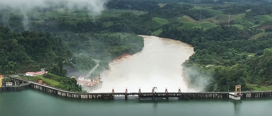
A weir style dam (sometimes called Kengbith Dam) holds back water in a head pond on the Nam Theun (river). Two underground tunnels carry water from the head pond down 240 meters in elevation to a power station located in Na Hin town (also known as Khoun Kham) far below in the Khounkham valley.

Satellite image below shows Na Hin town (also known as Khoun Kham):

The project operates under a 30-year build-operate-transfer (BOT) concession agreement with an option for a 10 year extension (of the initial project).
Andritz Hydro provided design, manufacturing and supply of electro-mechanical equipment for the project.
The Theun Hinboun hydropower project is considered a commercial success and produced good dividends and royalties over the first decade.
Theun Hinboun layout image below:

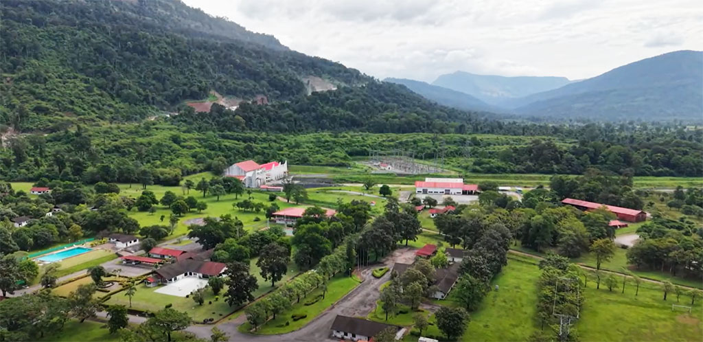
Theun Hinboun plant area image below:
Theun-Hinboun Powerhouse images below at coordinates 18°12'36.6"N 104°32'19.6"E (18.210176, 104.538788):


Expansion Project in 2012: After a decade of operation it was decided to expand the project by constructing a dam on the Nam Gnouang (river) which is a tributary river to the Nam Theun river. The reservoir now enables regulation of flows into the small Theun-Hinboun headpond.
The new dam is about 20 kilometers upstream from the existing Weir Dam & head pond. A new powerhouse with two 30 MW vertical axis Francis turbines (60 MW total) was constructed jusr below the dam.At the Na Hin plant facility, a new 220 MW vertical axis Francis turbine was installed in a powerhouse addition alongside the initial two 110 MW turbines. This now gives the overall project 3 powerhouses.
In 2016 & 2017 an additional 20 MW generating capacity was created by upgrades to the existing system.
Total combined generating capacity in 2026 is now 520 MW (110 + 110 + 60 + 220 + 20). Annual generation potential is roughly estimated to be about 2,000 GWh.
The Nam Gnouang Dam structure is 480 meters wide and 65 meters high with five gates that are opened only to discharge water to avoid flood events. The net head for the 60 MW power plant is only 47 meters.
The expansion works included a steel penstock 1,000 meters long with diameter ranging between 5.8 and 5.3 meters, a headrace tunnel with length of 300 meters and diameter of 11 meters and a 5,500 meters-long concrete-lined headrace tunnel with internal diameter of 6.5 (or 6.9) meters, located parallel to the existing tunnel and bored by Tunnel Boring Machine (TBM) method.
Theun-Hinboun Hydropower Project profile view layout in image below after the expansion project:

Much of the water from the Nam Gnouang reservoir is used to generate power twice - water flows first through two 30 MW turbines at the expansion dam site and then to the weir headpond and down through a new 900 meter penstock to the new powerhouse in Na Hin town.
The output sold to Thailand is transmitted through two 230 kV transmission lines running beside each other to a substation near Nakhon Phanom Thailand.
460 MW of the combined output is be sold to EGAT and the remaining 60 MW to Electricite du Lao (EDL).
The expansion project reservoir inundation required the resettlement of 4367 persons from 12 settlements in the reservoir area.
Images below for Nam Gnouang reservoir and intake structure below:


Nam Gnouang intake structure below viewing from the reservoir side before inundation. Looks like multiple levels available for intake.

From the Nam Gnouang Powerhouse the water flows a short distance down the Nam Gnouang (river) and into the Nam Theun (river) and then to the existing head pond at the Theun-Hinboun Weir/Dam. Somewhere near the Weir/Dam it seems the Nam Theun river name ends and the Nam Kading name begins - very strange since it is the same natural river that joins the Mekong at Pak Kading town.
The water released from the Na Hin powerhouse flows to a spillway and into a regulating reservoir before final release into the Nam Hai (river), a tributary of Nam Hinboun which flows into the Mekong. The project is a trans-basin diversion project that diverts water from the Nam Theun basin into the Nam Hinboun basin.
Theun-Hinboun Layout below:
Images below show upgrade of facilities project adding an additional 20 MW capacity:

Powerhouse interior image below:

Theun-Hinboun Control Room 1 image below:

Three different styles of generators and a rotor at Theun-Hinboun shown below:

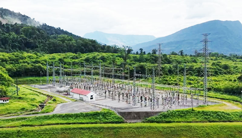
Theun-Hinboun Switchyard image below:

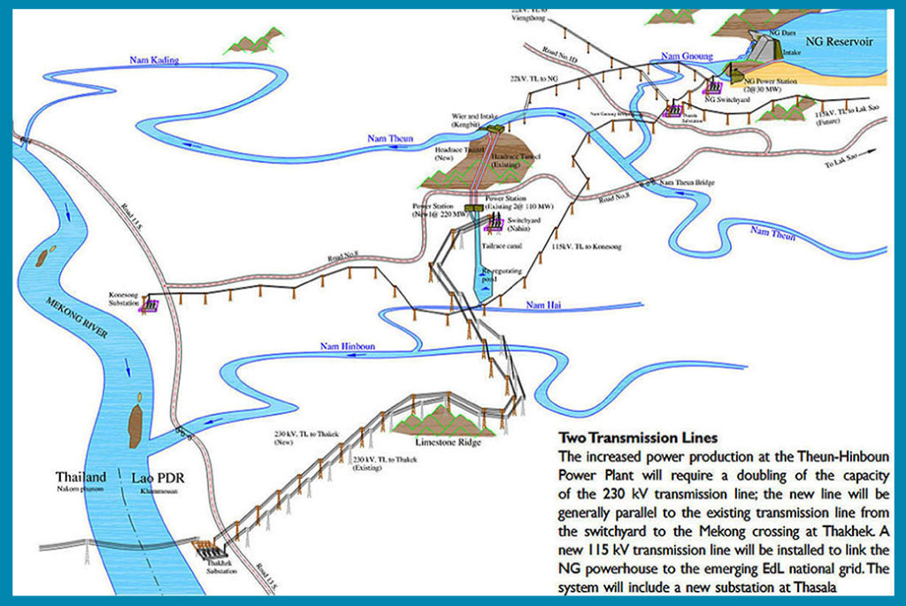
Location map below shows Theun-Hinboun Projects at the top in gray and pink ovals:

Cooperative Muratori & Cementisti C.M.C di Ravenna & Right Tunneling were contractors involved in the expansion project which created a second tunnel beside the initial tunnel. Tunnel-boring machine breakthrough image below after nine months of boring 6.9 meter diameter tunnel 5,500 meters from intake pond to powerhouse.

Theun-Hinboun tunnel diagram below:


Nam Gnouang reservoir total storage capacity is about 2,900 million cubic meters while effective active capacity in chart below is 2,262 million cubic meters.

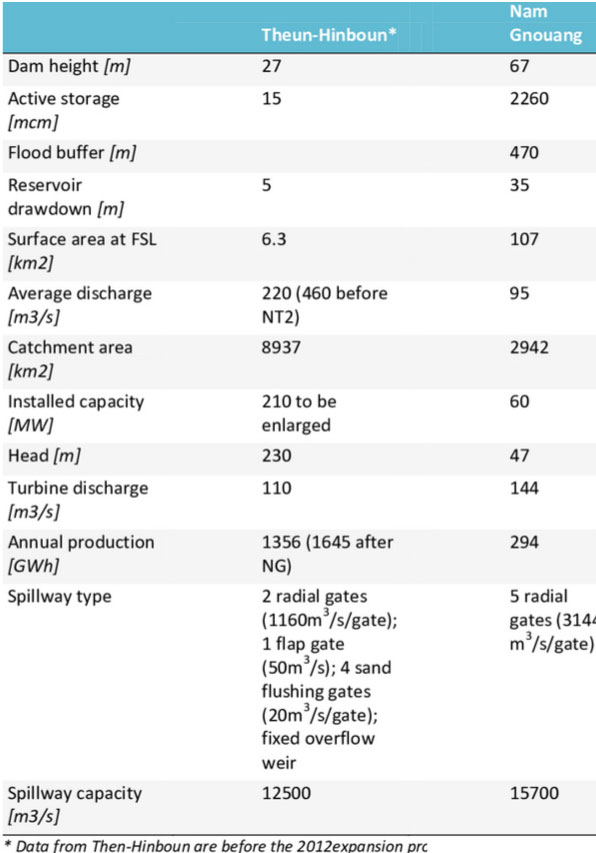
Theun Hinboun original project & Nam Gnouang add-on stats compared in chart below. Not all numbers in these comparison charts agree exactly:
Channel to regulating pond image below:


Theun Hinboun transmission power line images below:

440 MW (maybe 460 MW) of Theun-Hinboun's output is for export to Thailand by an 86 km long 230 kV transmission line to the border at Thakhek by the route shown in map below:
![]()
See enlarged version of map below HERE.

Theun Hinboun Nam Gnouang reservoir image below as of Oct. 2022 at end of rainy season:

Theun-Hinboun powerhouse image (before expansion) is on the Lao 20,000 kip banknote.

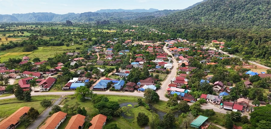
NaHin town (also known as Khoun Kham) image below with Theun-Hinboun golf course at bottom:
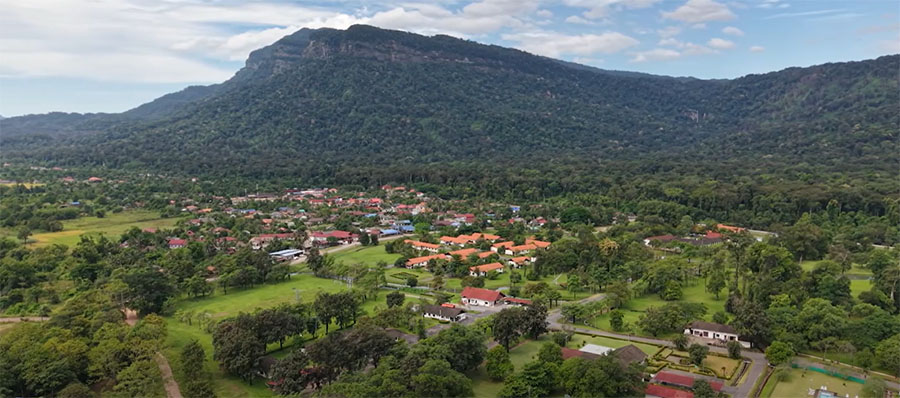
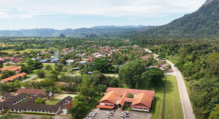
NaHin area images below:
See our map of Nam Theun Basin and Nam Hinboun Basin water drainage and catchment areas HERE
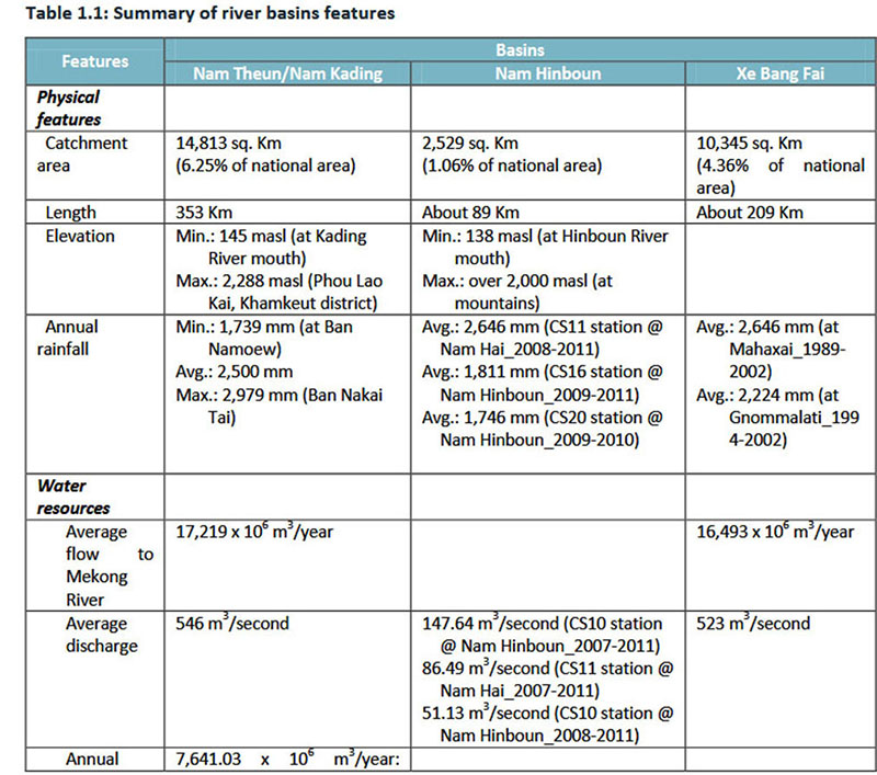
Southern Laos river basin comparison chart below:
The unrelated Nam Theun 2 hydropower project diverts much of the runoff from the Nakai Plateau away from the Nam Theun river and instead channels the flows south into the Xebangfai river which decreases the water flowing into Theun-Hinboun HPP and Nam Theun 1 HPP as seen in chart below.
